Minnesota Heat Wave: Heat, Humidity and the Ring of Fire
Minnesota’s Hottest Week of Summer? Heat, Humidity and the “Ring of Fire” Setup
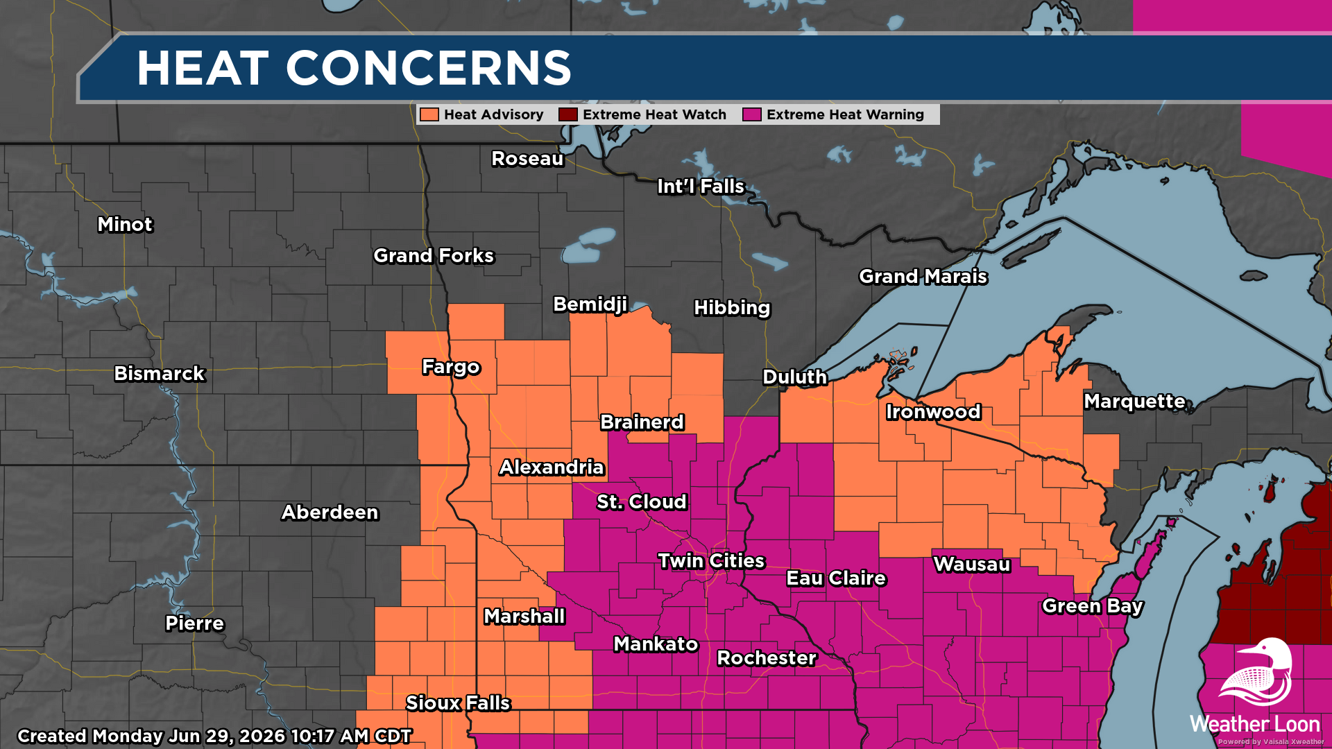
It's a Minnesota Heat Wave! Summers can bring just about everything from beautiful lake days, booming thunderstorms, high humidity, and the occasional stretch of dangerous heat. This week could feature one of the hottest stretches of the summer so far across the state as a strong ridge of high pressure builds across the central United States.
Temperatures will climb well into the 90s, but the real story will be the combination of heat and humidity. With tropical moisture surging north, dewpoints will climb, making it feel even hotter than the thermometer suggests.
Welcome to the classic Minnesota summer equation:
Heat + Humidity = Dangerous Heat Index Values
The Weather Setup: Building the Summer Heat Dome
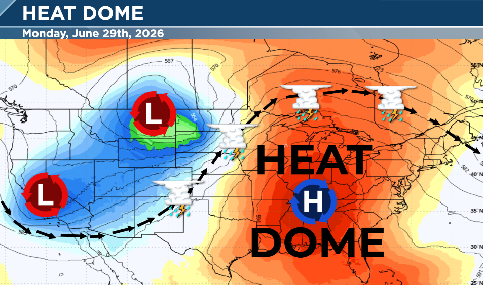
The weather pattern setting up this week is a familiar summer pattern: a strong area of high pressure building over the region.
Meteorologists often call this a “heat dome” because high pressure acts like a lid on the atmosphere. Air sinks underneath the ridge, skies often stay mostly sunny, and heat builds day after day.
The longer the ridge stays in place, the longer the heat stays in place. The challenge this week is that we are not just watching high temperatures, but we're watching the moisture and high humidity
Dewpoints: The Minnesota Humidity Factor
A temperature of 95° in Minnesota feels much different than a dry 95° in the desert.
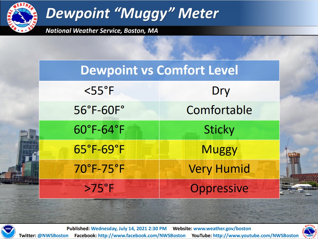
Why? Dewpoint. The dewpoint measures how much moisture is in the air. The higher the dewpoint, the more humid it feels. When dewpoints climb into the upper 60s and 70s, many Minnesotans start describing the air as “thick” or “soupy.”
That humidity matters because our bodies rely on evaporation of sweat to cool down. When the air is already loaded with moisture, sweat does not evaporate as efficiently, making it harder for the body to regulate temperature.
Heat Index: What It Really Feels Like
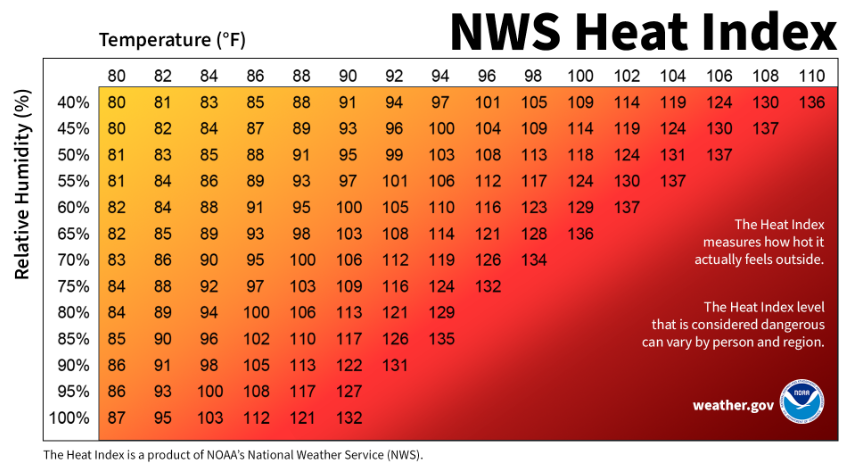
The heat index combines temperature and humidity to estimate how hot it feels to the human body.
For example: A temperature near 95° with high humidity can create heat index values near or above 100°.
The National Weather Service notes that heat index values are calculated for shady locations, and full sunshine can make it feel even hotter. That means a backyard, ball field, construction site, or parking lot can feel significantly hotter than the official forecast temperature.
Wet Bulb Globe Temperature: A Better Measure of Heat Stress
When we talk about extreme heat, most people are familiar with the heat index, the “feels like” temperature that combines air temperature and humidity.
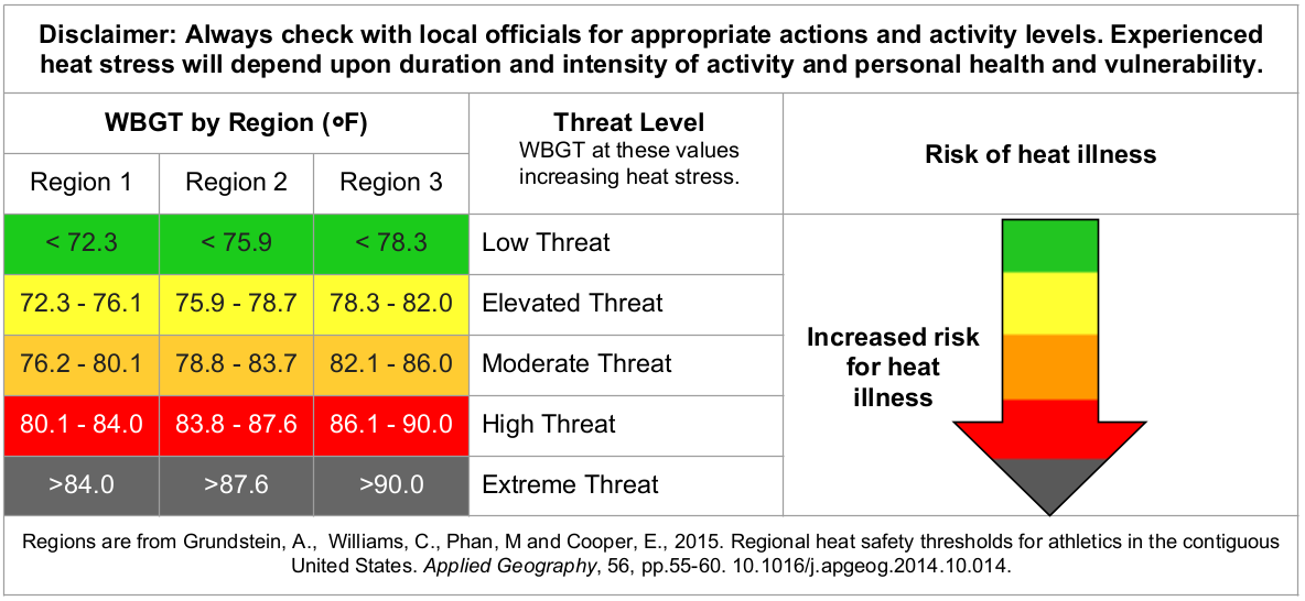
But meteorologists, athletic trainers, and safety professionals often look at another measurement called the Wet Bulb Globe Temperature (WBGT).
WBGT goes beyond temperature and humidity. It also factors in: Solar radiation (how much sun exposure there is), Wind speed, Humidity, Air temperature. In simple terms, WBGT estimates how much heat stress the human body experiences in the real world.
Think of it this way:
Heat Index:
“How hot does it feel based mostly on temperature and humidity?”
Wet Bulb Globe Temperature:
“How much heat stress is the body experiencing based on the entire environment?”
Both are valuable tools, but WBGT provides more information for situations where people are outside for long periods. Sweating is one of the body’s main cooling mechanisms. But when humidity is high, sweat evaporates more slowly, making it harder to release heat.
Add in direct sunshine, and the stress on the body increases even more.
That is why a sunny afternoon on a ball field, construction site, or lake can feel much more intense than the official air temperature suggests.
The NWS out of Wichita, KS has a great website to calculate the WBT. Check it out HERE:
Heat Is a Serious Weather Hazard
When people think about dangerous weather, tornadoes, hurricanes, and blizzards often come to mind. But heat is one of the deadliest weather hazards in the United States.
According to NOAA and National Weather Service information, heat-related illness and fatalities are a significant public health concern. CDC data has shown an average of more than 700 heat-related deaths per year in the U.S., including cases where heat was the underlying or contributing cause of death. Heat can also worsen existing health problems, especially during prolonged stretches of hot and humid weather.
Heat Safety: Protect Yourself During Extreme Heat
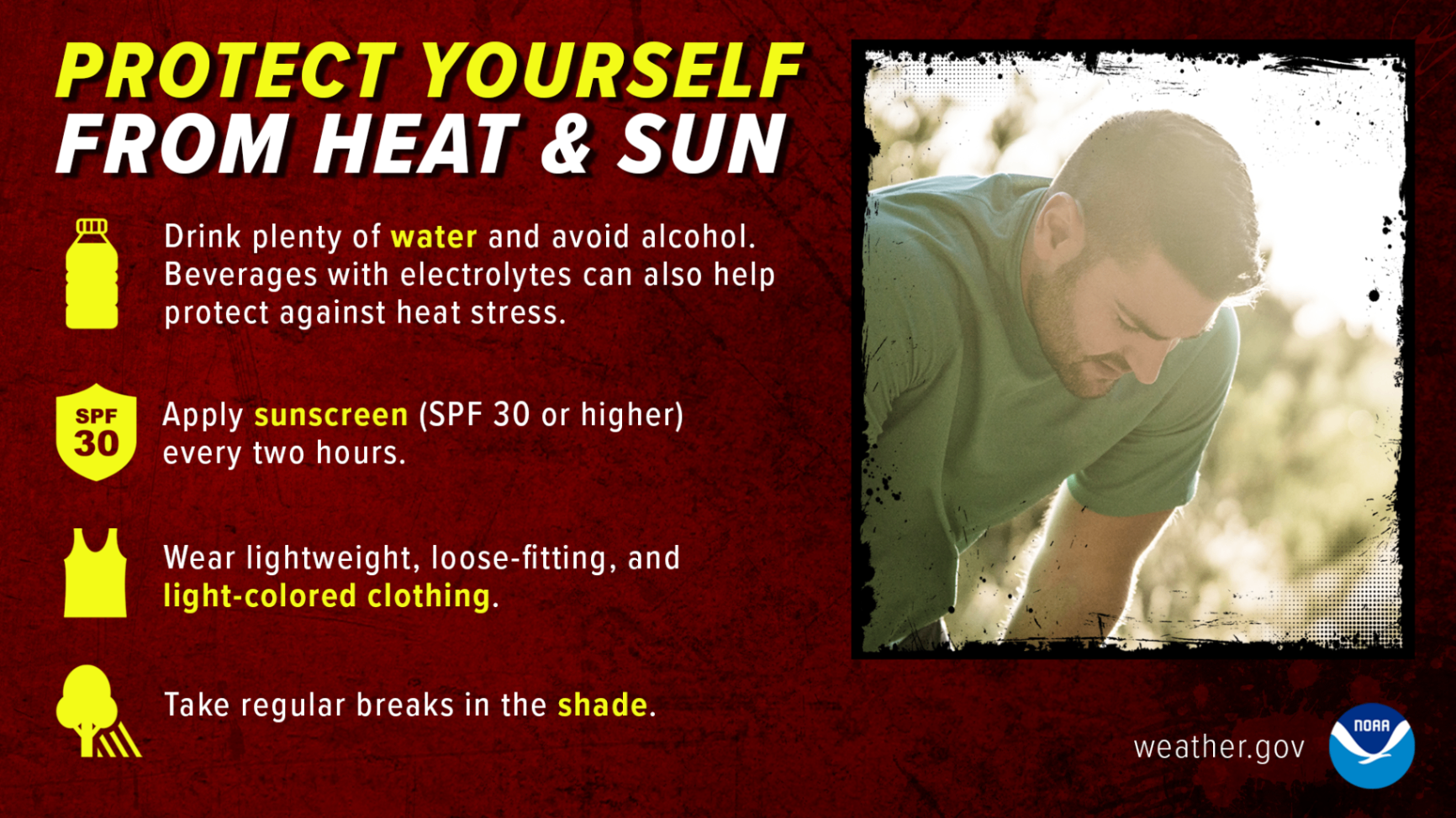
Extreme heat is not just uncomfortable, it can become dangerous. Some simple ways to stay safe:
*Drink plenty of fluids before you feel thirsty
*Avoid the hottest part of the afternoon when possible
*Take breaks if working outside
*Wear lightweight, breathable clothing
*Never leave children or pets in vehicles
*Check on neighbors, family members, and those most vulnerable to heat
Outdoor workers, young children, older adults, and people with certain health conditions are among those at higher risk during extreme heat.
Know the Signs of Heat Illness
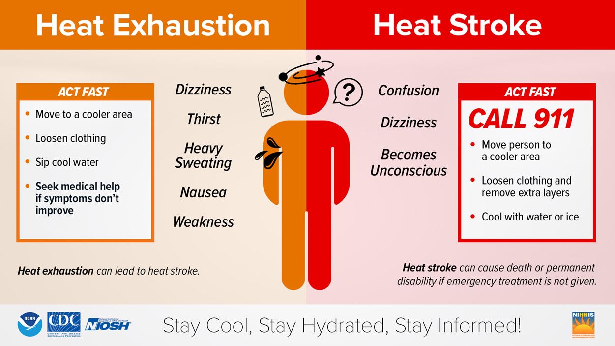
Heat can be very taxing on the body and can lead to heat related illnesses or make existing health conditions worse. Everyone can be vulnerable to heat, but some more so than others. According to The Impacts Of Climate Change On Human Health In The United States: A Scientific Assessment, Young children and infants, Older adults, People with chronic medical conditions, Pregnant women are also at higher risk.
Heat Exhaustion
Signs may include:
Heavy sweating
Weakness
Dizziness
Headache
Nausea
Muscle cramps
Move to a cooler location, drink fluids, and cool the body down.
Heat Stroke
Heat stroke is a medical emergency.
Warning signs include:
Confusion
Loss of consciousness
Seizures
Extremely high body temperature
Call 911 immediately if heat stroke is suspected.
The “Ring of Fire” Pattern: Heat, Storms and a Storm Highway
While high pressure builds heat across Minnesota, we may also be watching another summer feature: the ring of fire pattern. The “ring of fire” is a term meteorologists use for a pattern where thunderstorms repeatedly develop along the edge of a strong ridge of high pressure.
Instead of the center of the ridge producing storms, storms tend to fire up around the outside edge, often where warm, humid air meets cooler air and disturbances moving through the atmosphere.
For Minnesota, that can mean:
Hot and humid afternoons
Multiple rounds of thunderstorms
Heavy rainfall potential
Gusty winds and lightning
Localized flooding concerns
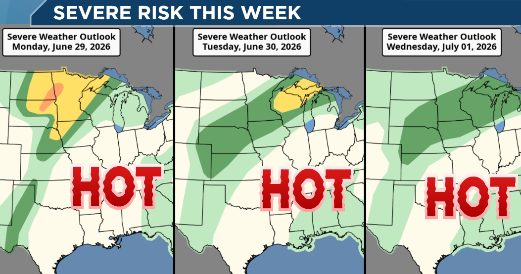
It can be a challenging forecast because one location may see sunshine and extreme heat, while another location nearby deals with storms. Here is a look at the Storm Prediction Center Severe Risk for Monday, Tuesday, and Wednesday of this week. Additional thunderstorms are possible later this week and into the week as well. As long as we're on the edge of the Heat Dome, the "ring of fire" will persist.
Minnesota Summer Reminder
Minnesota is known for dramatic weather swings, from snowstorms to severe thunderstorms to summer heat waves.
This week is a reminder that the hottest weather of the year can bring real risks. The combination of high temperatures, high dewpoints, and potential thunderstorms will make this a week to stay weather-aware. Stay hydrated, check the forecast, and keep an eye your friends and family.
Because in Minnesota, summer can be beautiful, but it can also bring some serious heat.
As always, you can watch the Weather Loon HERE 24/7 for the latest weather information: