El Niño Returns: What It Means for Minnesota This Winter
El Niño Returns: What a Strong or Very Strong El Niño Could Mean for Minnesota This Fall and Winter
A major shift is underway in the tropical Pacific Ocean, and it could have a big influence on weather patterns across the United States this fall and winter.
NOAA has announced that El Niño returns, marking the return of the warm phase of the El Niño Southern Oscillation (ENSO). Forecasts suggest El Niño could strengthen through the fall, potentially reaching Strong or even Very Strong levels by the peak of winter.
But what does a warmer Pacific Ocean thousands of miles away mean for Minnesota?
The answer comes down to how El Niño reshapes the jet stream, the fast-moving river of air high above the Earth that helps guide storms and influence temperature patterns.
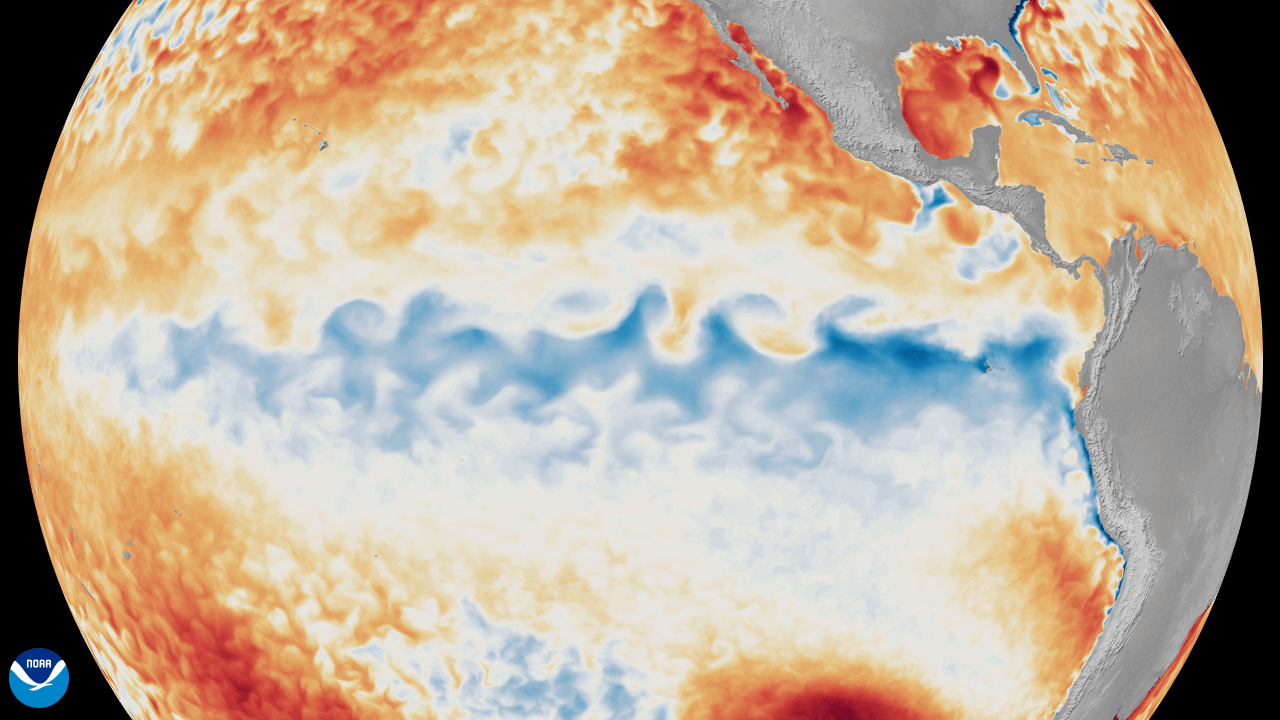
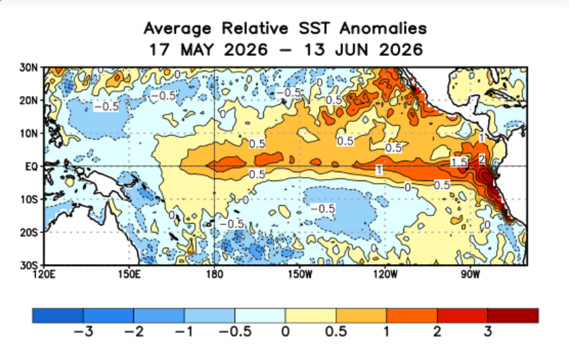
Here's a look at the most recent sea surface temperature anomaly in the Eastern Pacific, which shows warmer water temperatures in the region.
What Is El Niño?
El Niño (Spanish for “little boy”) occurs when ocean temperatures in the central and eastern tropical Pacific become warmer than average for an extended period of time.
Meteorologists officially classify El Niño when sea surface temperatures in the Niño monitoring region of the Pacific are at least 0.5°C above average for several months, along with changes in the atmosphere above the ocean.
Normally, tropical Pacific winds help push warm water westward toward Indonesia and Australia. During El Niño, those winds weaken, allowing warmer water to shift eastward toward South America.
This change affects the large-scale circulation of the atmosphere, including the position and strength of the jet stream.
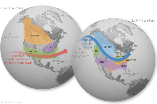
The difference between El Niño and La Niña during the winter months is shown in the typical weather patterns below. La Niña tends to bring cooler temperatures into the Midwest, while El Niño winters tend to be warmer.
Why Does El Niño Matter for Minnesota?
El Niño is typically strongest during the Northern Hemisphere winter, which is when its impacts are often felt the most across the United States.
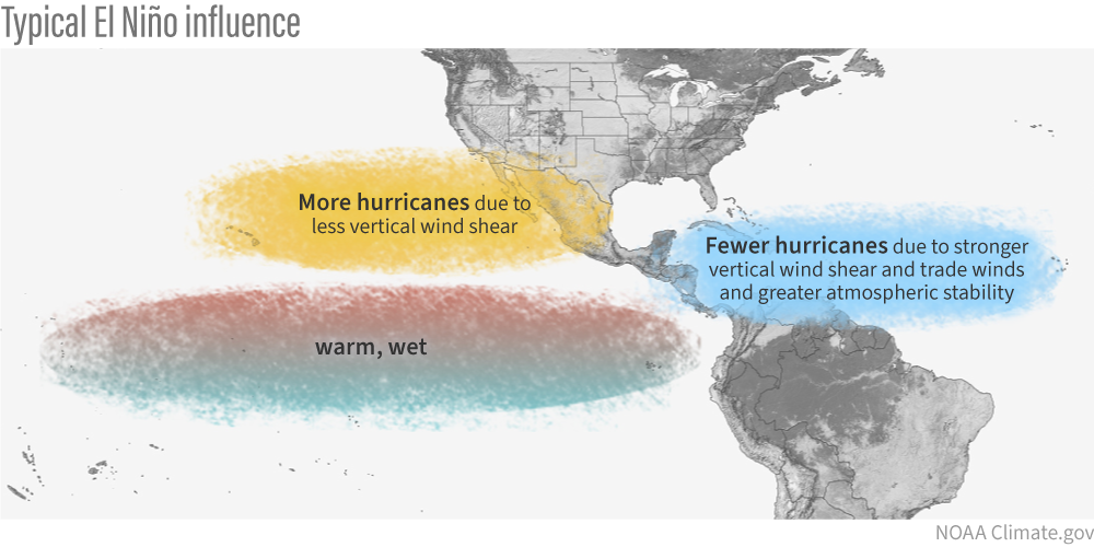
During a typical El Niño winter, the Pacific jet stream tends to shift south, sending more storms across the southern United States. This can bring increased precipitation chances to areas like California, the Southwest, and the Gulf Coast.
Meanwhile, the northern tier of the United States, including Minnesota, often trends warmer than average.
However, one important thing to remember:
Every El Niño is different.
Some El Niño winters are mild, while others bring major shifts in temperature and snowfall patterns. The strength of the El Niño, the location of warmer Pacific water, and other climate patterns all influence the final outcome.
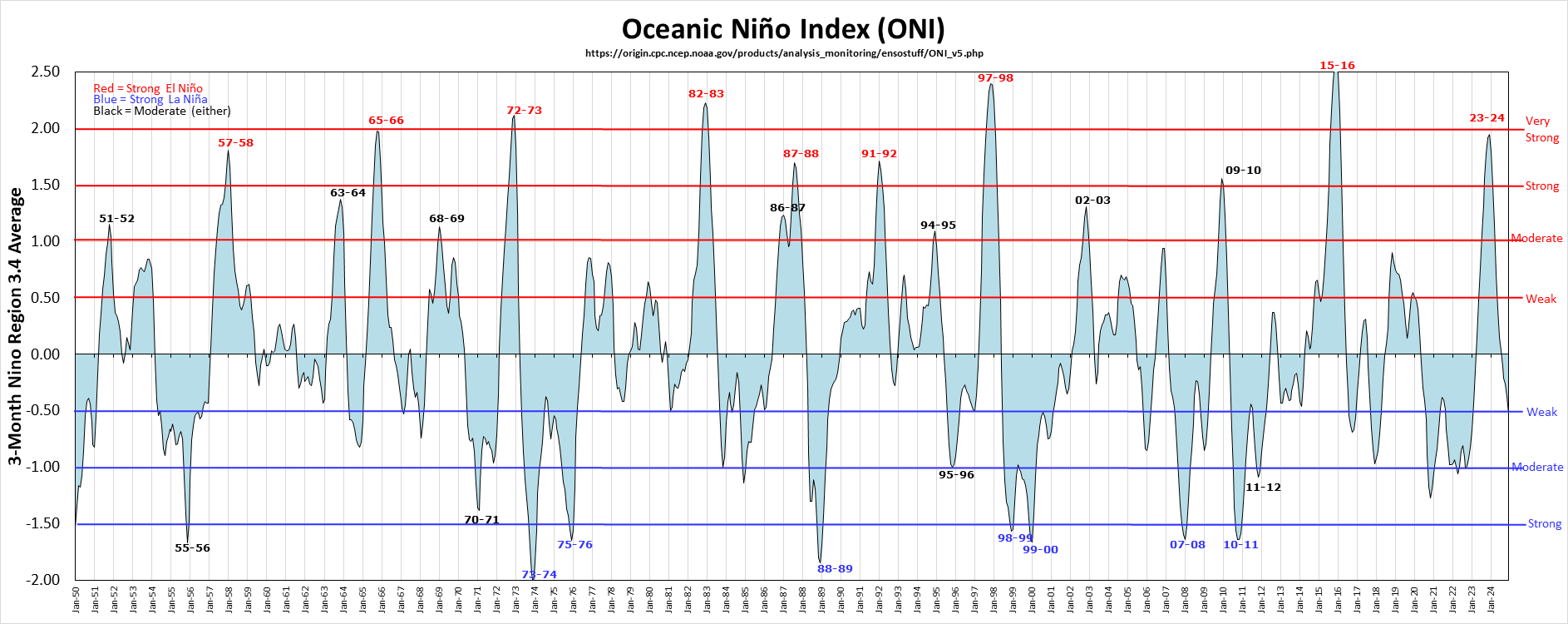
Here is a look at all of the El Niño and La Niña episodes since 1950
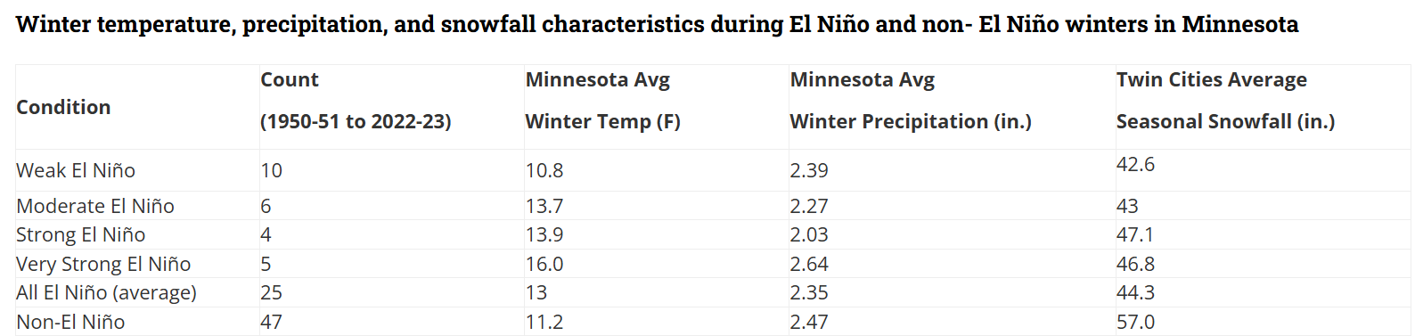
Minnesota Climatology and El Niño Winters
The Minnesota Climatology Office put together a detailed report of all the El Niño and non-El Niño winters since 1950. For the 25 El Niño winters we've experienced, the average is 13F, but there is a strong correlation between the strength of the El Niño, especially during Very Strong El Niños, where the average temperature in Minnesota jumps to 16F. Snowfall, overall tends to be a little lower than normal in the Twin Cities. KMSP typically averages around 52" and during non-El Niño winters, the average snowfall tends to be higher.
How Could a Strong El Niño Impact Minnesota?
For Minnesota, a strong or very strong El Niño could tilt the odds toward a warmer-than-average winter, especially across the northern United States.
That does not mean Minnesota will avoid cold snaps or snowstorms. Even during El Niño winters, Arctic air can still plunge south and major winter storms can still develop.
However, the overall pattern may favor:
Warmer Temperatures
Strong El Niño winters often feature a stronger Pacific jet stream and a storm track displaced farther south. This can reduce the number of prolonged cold outbreaks across the Upper Midwest.
Minnesota winters can still be snowy and cold, but the odds may lean toward temperatures running above average. According to the Minnesota Climatology Office, "the warmest December-through-February on record in Minnesota came during the very strong 1997-98 El Niño episode. The very strong events in 2015-16 and 1982-83; the strong El Niño in 1991-92; and the moderate one in 1986-87, also are associated with winters that are among Minnesota's 10 warmest on record."
Snowfall: More Complicated
Snowfall during El Niño winters can be tricky in Minnesota.
A warmer pattern does not automatically mean less snow. Storm tracks can still produce significant snow events when temperatures are cold enough.
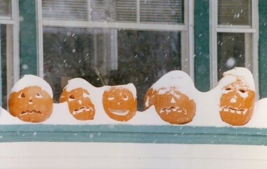
Historically, some El Niño winters have produced below-average snowfall in Minnesota, while others have delivered major snowstorms like the Halloween Blizzard of 1991!
The key question becomes:
Where does the storm track set up?
A storm track farther south often favors more snow across the southern U.S., while a farther north track can still bring snow opportunities into Minnesota.
Winter Storm Timing
One potential impact of El Niño is fewer frequent Arctic outbreaks but potentially more active storm systems when conditions line up. Minnesota could see stretches of quieter weather interrupted by impactful winter storms.
According to Minnesota's Climatology Office, "There are some notable exceptions. The Halloween Blizzard of 1991 occurred during a Strong El Niño event and was followed by other heavy snowstorms during November, making it the snowiest month on record at many locations. Mild and uneventful conditions did set in during the rest of the winter. In 1982-83, during a very strong El Niño, a mild and wet winter was punctuated by two outstanding blizzards--one in late December and one in mid-April. More recently, the weak El Niño of 2018-19 began with a warm "snow drought" that lasted through mid-January, but then gave way to an incredible winter barrage that included extreme cold and almost endless accumulating snow, which led to spring flooding across the state. The moral of the story is that El Niño tends to yield mild and low-snow winters, but extremely cold and extremely snowy exceptions are always just an Arctic cold front away in Minnesota!"
Read more about the Halloween Blizzard of 1991 from the Minnesota Historical Society HERE:
Could This Become a "Super El Niño"?
El Niño Returns and forecasters are watching closely because this El Niño may strengthen significantly.
NOAA monitors the intensity of El Niño using ocean temperature measurements in the tropical Pacific. If temperatures become more than 2.0°C above average in the Niño region, the event is classified as a Very Strong El Niño.
A very strong El Niño is relatively uncommon (there have only been 5 since 1950), and while it increases confidence in seeing a larger atmospheric response, it still does not guarantee a specific outcome for Minnesota. Past strong El Niño events have produced very different winter experiences depending on other atmospheric patterns.
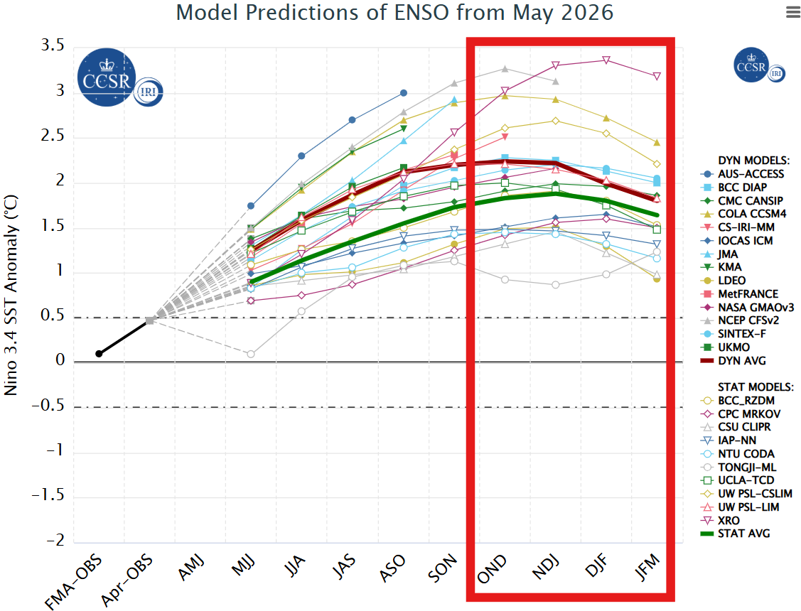
Here is the ENSO (El Niño Southern Oscillation) forecast by a number of different models as we approach the upcoming Fall and Winter. Note Dynamic and Static Average of the models in the BOLD Green and Red lines show a consensus toward temperatures nearing that 2F or Very Strong El Niño threshold.
What About Fall Weather in Minnesota?
While El Niño is usually most influential during winter, changes can begin showing up during the fall.
A developing strong El Niño can influence:
The position of the jet stream
Storm tracks across North America
Temperature trends
Early-season winter weather patterns
For Minnesota, fall could feature more variability as the atmosphere transitions toward the winter pattern.
We may still experience:
Warm stretches
Early cold snaps
Strong storm systems
Rapid temperature swings
That's very typical for Minnesota weather.
El Niño and Atlantic Hurricanes
El Niño also has impacts outside of winter weather.
A stronger El Niño often increases upper-level winds across the Atlantic Basin, which can create more wind shear — an environment that makes it harder for hurricanes to develop and strengthen.
That means El Niño years often have fewer Atlantic hurricanes compared to La Niña years.
However, the Pacific can become more favorable for tropical activity during El Niño.
What a Developing El Nino Could Mean for Minnesota
A strengthening El Niño could become one of the biggest weather stories heading into the upcoming fall and winter.
The pattern may favor:
A warmer-than-average winter across Minnesota
A potentially less persistent cold pattern
A storm track that requires close monitoring
Periods of active weather mixed with quieter stretches
But remember, El Niño is not a forecast by itself. It is one piece of the puzzle. Minnesota weather is influenced by many factors.
Don't forget to watch Weather Loon Live 24/7 HERE:
Meteorologist Todd Nelson
Praedictix