Severe Weather Returns This Week. June is an Active Month
Why June Is One of Minnesota's Most Active Severe Weather Months of the Year
If there is one month that stands out for severe weather across Minnesota and much of the Midwest, it's June.
From tornadoes and large hail to damaging winds and flash flooding, June is often the busiest month of the year for severe thunderstorms. The reason comes down to a perfect combination of heat, humidity, and atmospheric dynamics that create an environment favorable for explosive thunderstorm development.
The Ingredients Come Together in June
By June, the Upper Midwest has warmed significantly compared to spring. Longer days and a higher sun angle allow temperatures to climb well into the 70s and 80s, while increasing moisture streams northward from the Gulf.
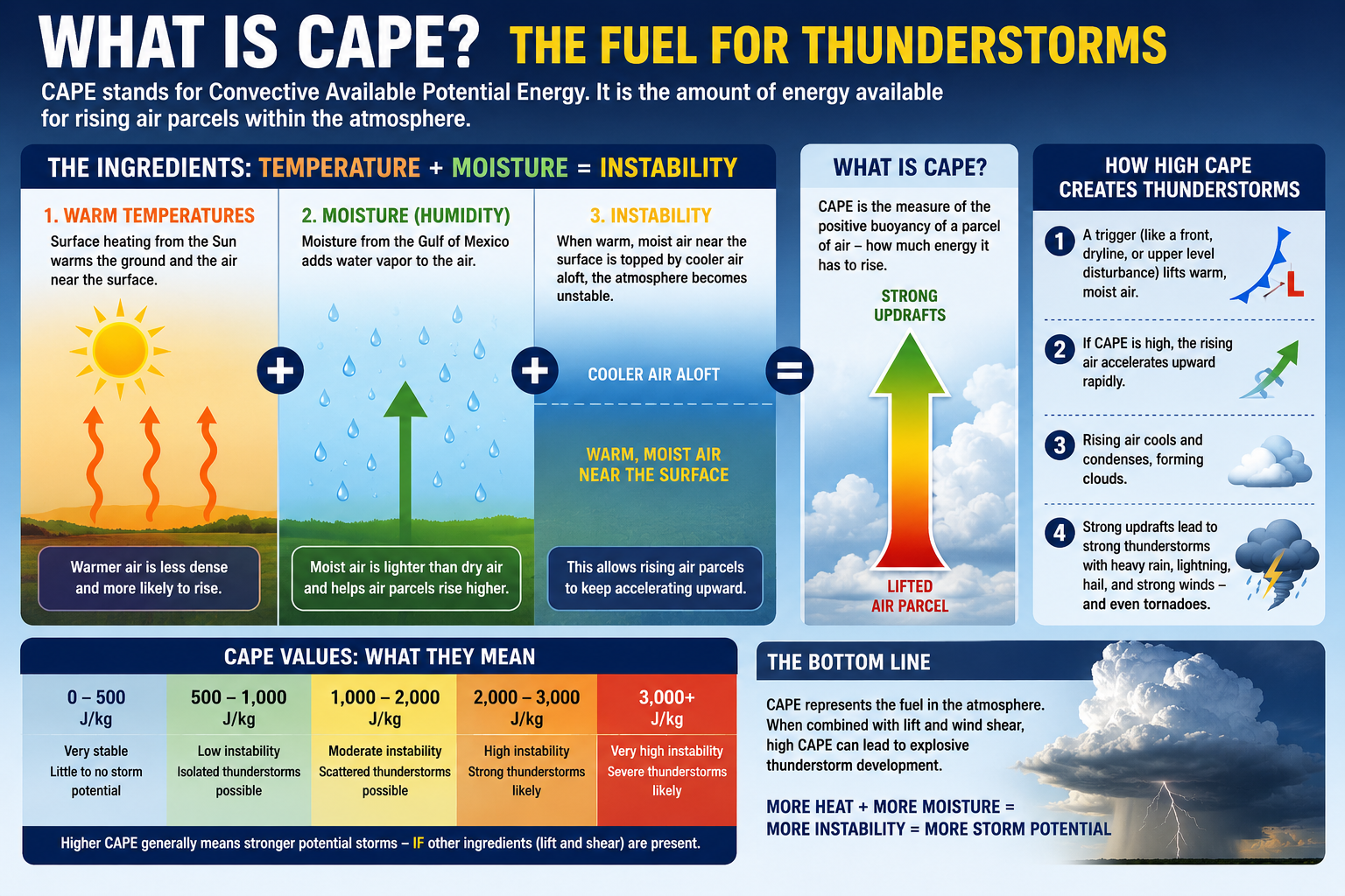
This combination of warmth and humidity creates larger amounts of Convective Available Potential Energy (CAPE), one of the primary fuels for thunderstorms.
CAPE measures the amount of energy available for rising air parcels within the atmosphere. In simple terms, higher CAPE values mean air can rise faster and thunderstorms can become stronger.
As dew points climb into the 60s and even lower 70s, the atmosphere becomes increasingly unstable. When a cold front, warm front, or upper-level disturbance arrives, thunderstorms can rapidly develop and intensify.
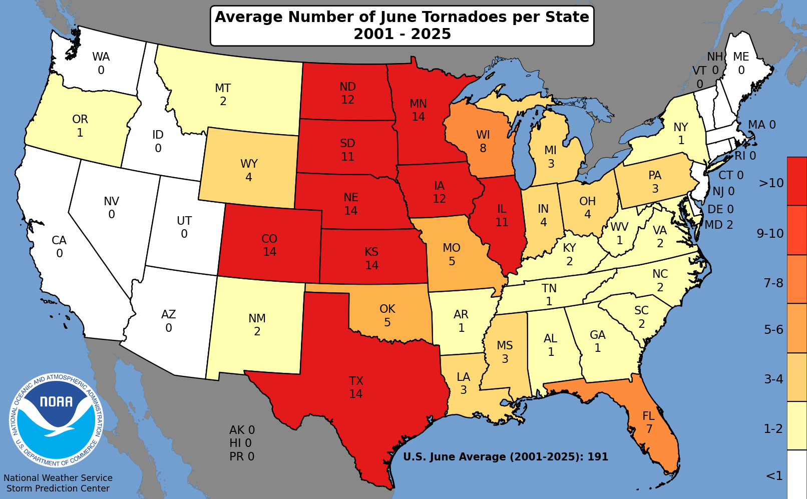
June Leads the Year in Tornado Activity
June is historically Minnesota's most active month for tornadoes. While tornadoes can occur any month of the year, the overlap of strong instability, increasing wind shear, and frequent storm systems peaks during early summer.
The combination of:
Strong daytime heating
Rich Gulf moisture
Active jet stream dynamics
Frequent frontal boundaries
creates an ideal setup for rotating supercell thunderstorms capable of producing tornadoes. Many of Minnesota's most memorable severe weather outbreaks have occurred during June, including significant tornado events, widespread wind damage, and large hail episodes.
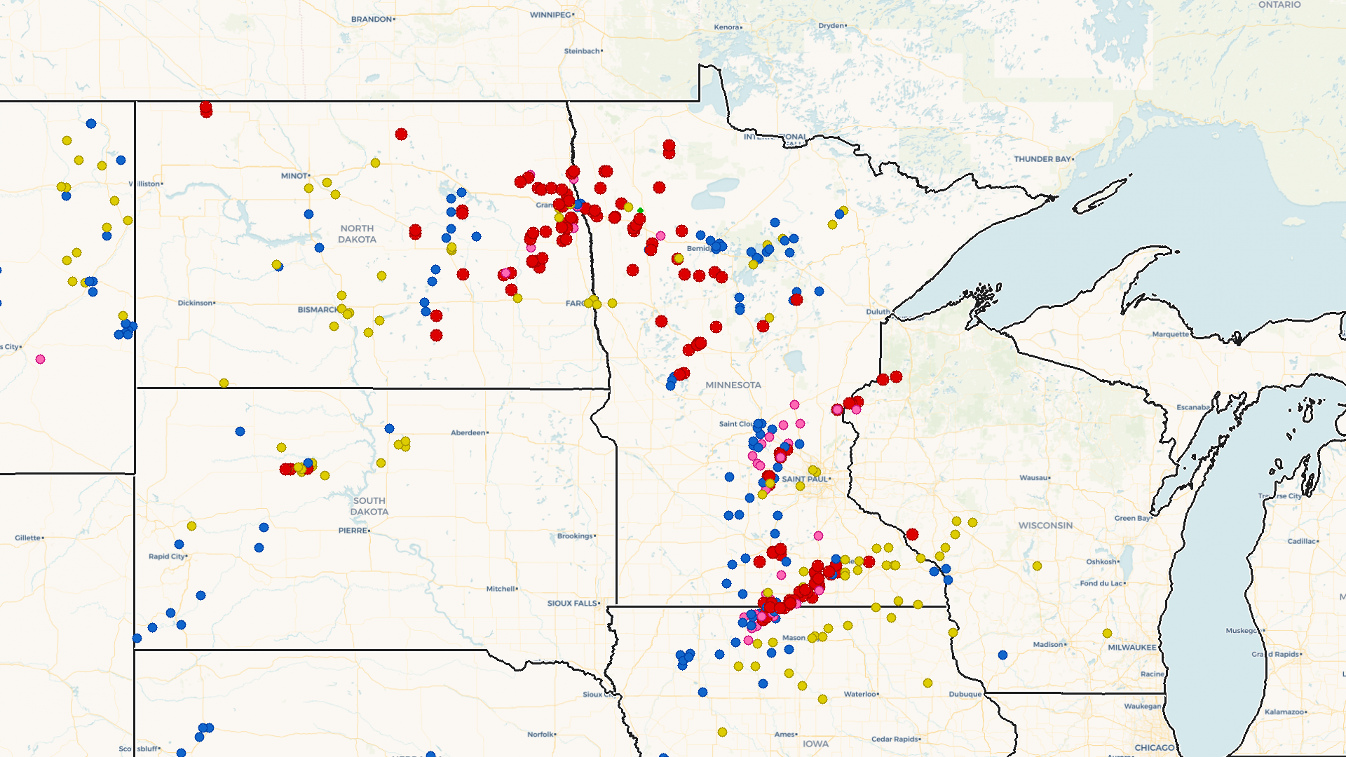
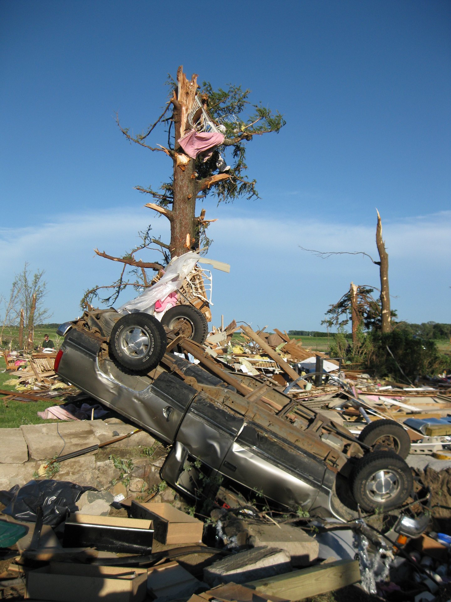
June 17, 2010: Minnesota's Largest Tornado Outbreak on Record
One of the most significant severe weather events in Minnesota history occurred on June 17, 2010, when a powerful storm system produced a record-setting 48 tornadoes across the state in just six hours. The outbreak affected 22 counties and generated widespread damage from tornadoes, destructive winds, large hail, and flooding rains.
The event claimed three lives in widely separated locations near Mentor, Almora, and Albert Lea, while dozens more were injured. Among the 48 tornadoes, 15 were rated EF-2 or stronger, including four EF-3 tornadoes and three violent EF-4 tornadoes. The hardest-hit communities included Wadena, where entire neighborhoods were devastated.
The outbreak shattered Minnesota's previous single-day tornado record of 27 tornadoes set in 1992 and remains one of the most extraordinary severe weather events ever documented in the state. Its combination of geographic coverage, tornado intensity, and overall destruction serves as a reminder of why June is considered the peak month for severe weather across Minnesota.
See more from the Twin Cities National Weather Service HERE:
The Midwest Severe Weather Peak
Minnesota isn't alone.
June is often the peak month for severe weather across much of the Upper Midwest and Northern Plains. During this time of year, the jet stream frequently interacts with warm, moisture-rich air surging northward from the Gulf of Mexico.
The result is a corridor of severe weather stretching from the Dakotas through Minnesota, Iowa, Wisconsin, and into portions of the Great Lakes.
Severe Weather Threat Returns This Week
Not surprisingly, June is living up to its reputation this week.
A very warm and increasingly humid air mass is moving into Minnesota, while multiple disturbances track across the Northern Plains and Upper Midwest. This setup will bring several opportunities for severe thunderstorms.
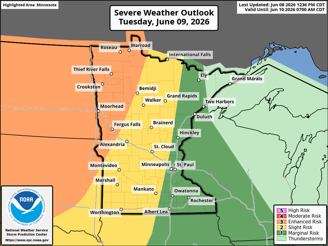
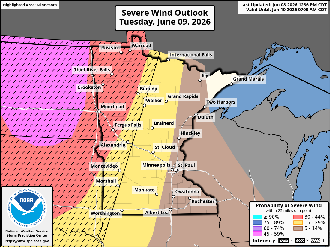
Tuesday: Enhanced Risk in Northwest Minnesota
The Storm Prediction Center has placed portions of northwestern Minnesota under an Enhanced Risk (Level 3 of 5) for severe thunderstorms Tuesday.
Storms developing across the Dakotas are expected to move eastward into Minnesota during the afternoon and evening hours. Large hail, damaging winds, and isolated tornadoes will all be possible depending on storm mode and timing. Forecast discussions continue to highlight increasing heat and humidity ahead of the approaching system.
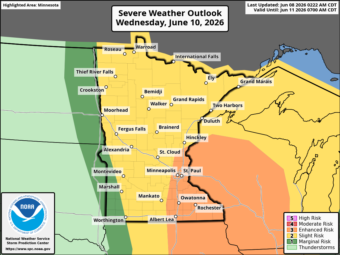
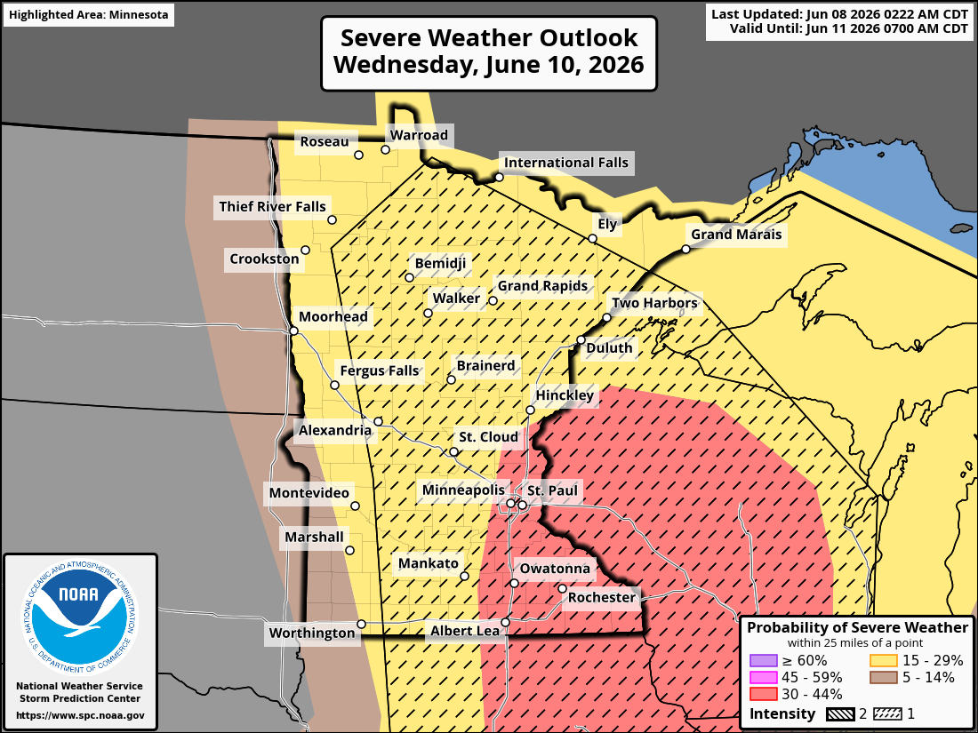
Wednesday: Enhanced Risk Expands into Southeastern Minnesota
Attention then shifts to southeastern Minnesota and the Twin Cities metro on Wednesday.
The Storm Prediction Center has outlined an Enhanced Risk (Level 3 of 5) for portions of southeastern Minnesota as another round of thunderstorms develops along a strengthening frontal boundary. Forecasts indicate a warm, humid environment capable of supporting strong to severe thunderstorms.
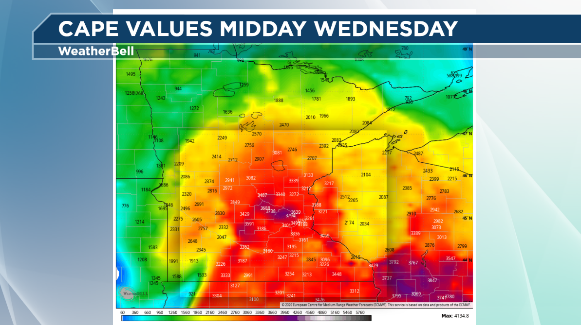
One of the key ingredients on Wednesday will be increasing instability.
Forecast models suggest CAPE values may climb into the 2,000-4,000+ J/kg range across portions of southern and eastern Minnesota, indicating an atmosphere loaded with potential energy for vigorous thunderstorm development. When combined with sufficient wind shear, these environments can support supercells capable of producing large hail, damaging winds, and tornadoes.
High CAPE doesn't guarantee severe weather, but it does provide the fuel storms need to become intense when other ingredients are present.
The Bottom Line
June is severe weather season in Minnesota.
Warmer temperatures, increasing humidity, and higher CAPE values combine with active weather patterns to make this the most active month for thunderstorms and tornadoes across the state. This week's forecast serves as a perfect example of why June has earned that reputation, with multiple rounds of severe weather possible and several areas highlighted by the Storm Prediction Center for enhanced severe weather risks.
As always, be sure to have multiple ways to receive weather warnings and stay tuned for forecast updates as storm details become clearer.
Don't forget, you can always watch WeatherLoon Live HERE
Meteorologist Todd Nelson